170 - AS III.43 (click to view in Digital Bodleian)
170 - AS III.43 (flap lifted) (click to view in Digital Bodleian)
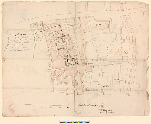
170 - AS III.43. Site plan of the streets S of Fleet Street, including an unexecuted design for a church on the Whitefriars site, probably made for the Commission for Building Fifty New Churches. Drawn by William Dickinson to a scale of just over 100 ft to an inch (drawn scale). Brown ink and pencil, shaded with pink wash. Watermark: horn in shield; DA. 331 x 421 mm. Inscribed on a small flap attached with wax (76 x 94 mm): A – ffromsons Court / B – Esex Court / C – Asentree Court / D – Davises yard / E – Crown Court / No 1. Blak Lyon Inn / 2–3 all dogwell Court. Inscribed below plan: South from Ashentree Court, followed by calculations. There are pencil dimensions on the streets next to the church.
Note to 170: This drawing presumably dates from late 1711, when plans were afoot to create a new parish in the Whitefriars area. The secretary of the building committee of the Commission for Building Fifty New Churches was ordered to 'write to [the] overseers of poor for White Friars for [an] account of constitution and condition of that precinct'. A report was duly received, but this is the last we hear of it; on 4 December Dickinson was instructed 'to inquire for [a] site […] to the north of Fleet Street' (Port 1986, 4, 148, 150, 155; Bill 1979, 38). The Whitefriars area, which is shaded pink, consisted of 'slums (called “Alsatia”), teeming with felons and debtors' (Bradley and Pevsner 1997, 624). The hatched blocks presumably depict the envisaged parish. The proposed church is basilican in plan, with a tower in the SW corner.
[WS 12, pl. 29, top; WS 18, pl. 2, bottom]