Only a handful of drawings survive for Wren's Winchester Palace: two plans at All Souls (291–292), and two elevations formerly in the Bute collection and today at Winchester. The palace was begun in 1683 but abandoned following the death of Charles II in 1685. The history of the project is given in HKW 5.304–13 (see also Cook 1970, Thurley 2000, and Jardine 2002, 331–38).
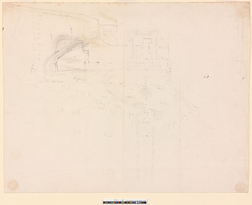
290 - AS IV.65. Survey plan of an unidentified castle, possibly Winchester in 1682. Pencil sketch by Wren, with dimensions in chains and feet, and annotations describing the contours of the site. There are two drawn scales in the top R corner, neither of which agrees with the dimensions. 361 x 467 mm. Watermark: Strasbourg lily; IHS surmounted by a cross. The inscriptions include the following, often several times: Way within the wall, Mount, The Mount, steepe, knole, path way, Ditch, Walks, before, precipice, flat, Bottom, decline, browe, water, wood.
Note to 290: This drawing can be tentatively associated with the medieval castle at Winchester, which Wren surveyed and measured in late 1682 (HKW 5.304). The basic contours of the site agree with Winchester (HKW 2.856; HKW 5.307), but it is difficult to reconcile the angle bastions with the architectural history of the medieval palace. Nor is there any indication of the surviving Great Hall.
Preliminary design, c. 1682–83 (291-292):
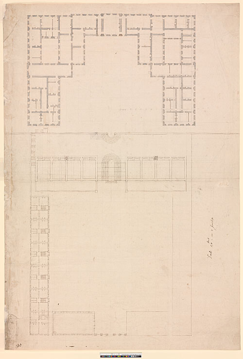
291 - AS II.98. Plan, showing the palace at state level and the forecourt buildings at ground level. The design is drawn over a pencil grid of rectangles, 23 x 24 ft (23 x 36½ ft along the central axis). The palace is lightly overlaid in pencil with the block plan of a revised design at ground-floor level (redrawn in HKW 5.306; Cook 1970, 59). The whole drawn by Wren to a scale of just under 25 ft to an inch (drawn scale). Dark brown ink over pencil, shaded with a grey wash (preliminary design); pencil over scorer (revised design). 696 x 472 mm. Watermark: Strasbourg lily WR, over JJ; IHS surmounted by a cross, over PT. The semicircular forecourt steps have been altered in pencil. The revised plan includes indications of chapels in the rectangular rooms immediately flanking the internal courts. Inscribed in ink, possibly by Hawksmoor: Scale 50 foot in 2 inches. Endorsed in ink (two hands): Winton; Churches to Grave.
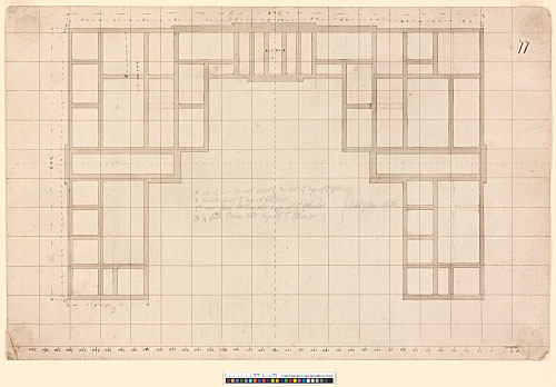
292 - AS IV.77. Basement plan of the preliminary design, drawn to a slightly smaller scale than 291 (drawn scale: just under 26 ft to an inch). The design is again gridded with rectangles measuring 23 x 24 ft (23 x 36½ on the central axis). Brown ink over pencil and scorer, shaded with a grey/brown wash. 269 x 416 mm. Watermark: IHS surmounted by a cross, over ET. The internal walls have been scratched out in several places. Inscribed in pencil by Wren: A all of one levell 1 foot 1/2 under ye top of ye flore / B levill with ye top of ye flore / C one foot below the top of ye flore / D 4 foot below the top of ye flore / both sides Alike. Pencil calculation on verso.
Note to 291-292: These two drawings record an early version of the design. The principal dimensions of the plan at this stage (generated by the ruled grid) are 328 ft (width), 214 ft (depth), and 63½ ft (width of side wings), while the equivalent dimensions in the revised design (as drawn in pencil over 291) are approximately 315 ft, 208 ft, and 60 ft. The pencil plan on 291 provides the fullest record of the revised design. 291 is presumably the 'general plan of the situation, with the plan and orthography of the royal Palace at the City of Winchester' listed in Parentalia.
[Wren 1750/1965, 325; WS 7.12–13, 15, 249, and pls. 1–2; HKW 5.305, n. 7; HKW 5.308, n 1; Cook 1970]
Drawings elsewhere: The following drawings, formerly in the Bute collection, are now at Winchester City Museum:
- (i) Preliminary E elevation, drawn by Wren (Downes 1971b, fig. 25; Whinney 1971, 152–53; Downes 1982b, 92 (fig. VI.5); Summerson 1953/93, fig. 194). This probably corresponds to the preliminary version of the plan on 291 (HKW 5.305, n. 7). The fenestration, however, does not agree exactly.
- (ii) Revised E elevation, drawn by Hawksmoor (Cook 1970, fig. 37; Downes 1971b, fig. 79; Downes 1982b, 92 (fig. VI.5)). This probably shows a further revision to the design, made c. 1685 (HKW 5.311).
[Missing iii and iv – see printed catalogue]
The engraved perspective view in Milner's History of Winchester (WS 7, pl. 4) was, according to the printed inscription, copied from a lost drawing 'by the architect himself' (Cook 1970, 63, n. 10).
The following documents survive at All Souls:
- (i) AS II.97 [Images: p.1, pp.2-3, p.4]: Explication of the Plan of Winchester Castle. Autograph manuscript by Wren, printed in WS 7.17–19. This probably relates to the preliminary scheme, since it describes a plan 'divided into squares by white lines each of which squares are 24 foot' (see 291–292). It is discussed at length in Thurley 2000.
- (ii) AS II.96 [Images: p.1, pp.2-3, p.4]: A Brief Abstract of all the Lands and Tenements purchased for the Accomoda[t]ion of the Kings Intended pallace at Winton. Original manuscript, not in Wren's hand. Printed in WS 7.19–20 (with the prices added from another source).